
Most El Nido articles tell you where to go; this one explains what you are actually looking at. Bacuit Bay is a drowned karst landscape, and once you understand how limestone dissolves, cracks and collapses, the lagoons, cathedral-like caves and needle-sharp cliffs stop looking random. This guide focuses on the geology of Bacuit Bay specifically for curious travelers who want to read the scenery during island-hopping tours, not just photograph it.
- What Is Karst, and Why Does It Matter Here?
- How Bacuit Bay Formed: A Simplified Timeline
- Reading the Rock: Features to Spot on Your Tour
- Karst Features Compared: Where to See Each One
- Why the Water Is So Clear Around the Cliffs
- Karst and Coral: A Fragile Partnership
- How to Photograph and Explore the Geology Responsibly
- Frequently Asked Questions
What Is Karst, and Why Does It Matter Here?
Karst is the name geologists give to landscapes shaped mainly by the chemical dissolution of soluble rock, usually limestone or dolomite. Rain absorbs a little carbon dioxide from the air and soil, becoming weakly acidic carbonic acid. Over thousands of years that slightly acidic water widens cracks in carbonate rock, carving out sinkholes, tunnels, caves and sharp fluted surfaces. Where the rock is thick and the climate is warm and wet, the result is dramatic, and northern Palawan qualifies on every count.
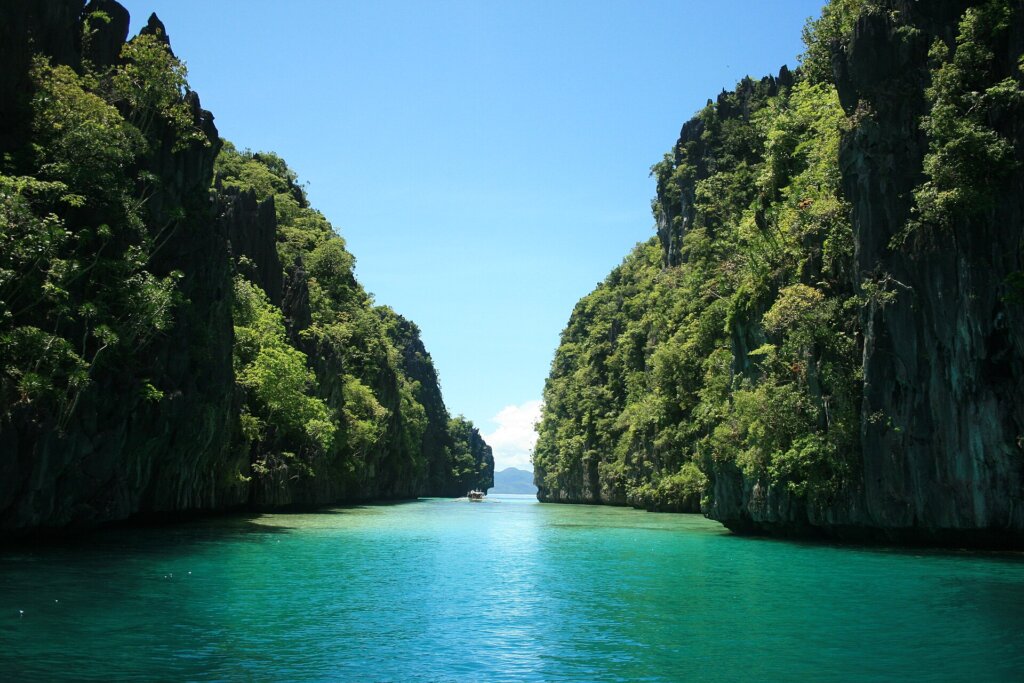
The cliffs that frame El Nido town and rise from Bacuit Bay are the most photographed example in the Philippines. Their vertical faces, undercut bases and honeycombed walls are textbook karst features. The reason the scenery feels so different from a typical volcanic Philippine island is simply the bedrock: you are on the edge of a limestone and marble belt rather than a young volcanic arc.
Understanding this also explains practical things travelers notice: why beaches are small and tucked into coves, why the water can be startlingly clear near the cliffs, why the rock is razor-sharp underfoot, and why caves and lagoons are hidden behind narrow openings.
How Bacuit Bay Formed: A Simplified Timeline
Geologists describe the El Nido area as part of the northern Palawan block, a fragment of continental crust that drifted away from the Asian margin. Thick layers of marine limestone were laid down on ancient seabeds, built up from shells, coral and calcareous mud. Later uplift pushed those layers above sea level, where rain and rivers began sculpting them.
The sculpting stage is where the postcard scenery comes from. Fractures in the rock guided water underground. Some passages widened into caves, and some cave roofs eventually collapsed to form enclosed basins, which is one way lagoons like the ones on the standard tours are thought to have originated. Finally, sea level rose after the last ice age, flooding the lower valleys and leaving the tall limestone remnants standing as islands. That flooded, island-studded landscape is Bacuit Bay today.
The exact ages and sequence are debated and are best confirmed with local geological surveys, but the broad story is consistent: deposition, uplift, dissolution, then drowning.
Reading the Rock: Features to Spot on Your Tour
You do not need a geology degree to notice the main karst features. Here is what to watch for from the boat and at each stop.
Notches at the waterline
Look at the base of any island cliff. A horizontal groove eaten into the rock just above the sea is a tidal notch, created by wave action, dissolution and marine organisms working at the same level for a long time. It makes many islets look like mushrooms.
Karren, or sharp fluted rock
The knife-edged, pitted surface you feel on Hidden Beach’s rocks or when climbing to a viewpoint is karren. Water runs across bare limestone and etches grooves. Wear sturdy water shoes, because it cuts skin easily.
Caves and overhangs
Sea caves form where waves exploit weaknesses at the base of a cliff, while older dissolution caves sit higher up. Stalactites and flowstone hanging from cave ceilings are calcite deposits left as mineral-rich water drips. For more on the human and ecological side of local caves, see our guide to Ille Cave and Dewil Valley.
Enclosed lagoons
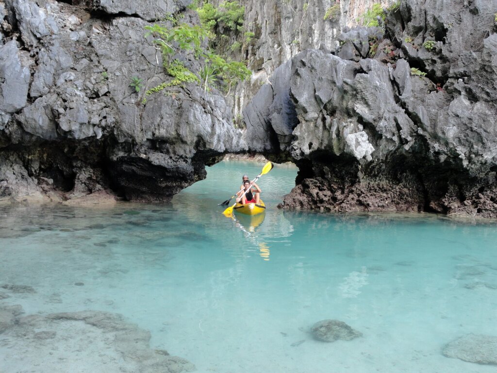
A lagoon with a narrow entrance and towering walls usually occupies a collapsed or flooded cavity. The still, sheltered water is why it looks so intensely turquoise on calm days.
Karst Features Compared: Where to See Each One
Different tour stops show off different parts of the story. The table below is a quick cheat sheet. Stop names and details vary by operator and season, so treat it as a guide rather than a guarantee.
| Karst feature | What it looks like | Typical place to notice it | What to bring |
|---|---|---|---|
| Tidal notch | Horizontal groove at the base of a cliff, giving a mushroom shape | Almost every islet along the standard routes | Camera at boat level |
| Karren (sharp rock) | Pitted, razor-edged limestone surface | Rocky beach edges and viewpoint trails | Water shoes, light gloves optional |
| Collapsed-cave lagoon | Sheltered basin with a narrow entrance | The lagoon stops on Tours A and C | Kayak or paddle board, waterproof phone pouch |
| Sea cave | Wave-cut opening at sea level | Cliff bases around the bay | Helmet or hat, careful footing |
| Flowstone and stalactites | Smooth calcite drapes in cave interiors | Inland caves reached with a guide | Headlamp, grippy shoes |
| Fringing reef on limestone | Coral growing on the submerged rock base | Snorkel stops near cliff bases | Mask, reef-safe sunscreen |
If you are planning a full route, our marine life and underwater guide pairs well with this cheat sheet.
Why the Water Is So Clear Around the Cliffs
Travelers often ask why Bacuit Bay water looks so clean. Part of the answer is geological. Limestone islands shed very little fine mud compared with soil-covered volcanic slopes, so there is less sediment washing into the bay after rain. Coral reefs tend to grow well on the submerged limestone base, and the bay’s sheltered layout reduces wave-driven turbidity on calm days.
Visibility still changes with weather, tide, and season. After heavy rain or strong winds, plankton and suspended particles can cloud the water for a day or two. Check conditions the evening before, and read our low-tide rock pool guide if you want to time a shoreline walk around the tide.
Karst and Coral: A Fragile Partnership
The same limestone that makes the scenery is also what reefs settle on, and both are more delicate than they look. Stepping on karren can break off pieces that took centuries to form, and standing on coral can kill polyps in seconds. Because limestone dissolves, it is also sensitive to pollution: acidic runoff, sunscreen chemicals and plastic waste travel quickly through porous rock and into the water.
Simple habits help: stay on marked trails, do not touch stalactites (skin oils stop the calcite from growing), keep fins off the bottom, and pack out every piece of trash. Read our coral conservation guide for practical do’s and don’ts, and review the El Nido-Taytay protected area rules before you book.
How to Photograph and Explore the Geology Responsibly
The best light on the cliffs is usually early morning and late afternoon, when low sun rakes across the rock and highlights texture. Midday sun flattens the walls and washes out the water color. A polarizing filter helps cut glare from the sea, and a wide lens captures the scale of the overhangs. If you are considering aerial shots, check local restrictions first in our drone photography rules guide.
For deeper background reading, the Department of Environment and Natural Resources, the Philippine Department of Tourism, and the UNESCO World Heritage Centre publish material on protected karst and marine areas that is useful context for the bay. Palawan is also home to the famous Puerto Princesa Underground River, another karst system worth comparing if you are extending your trip. You can find diving and snorkeling standards at PADI.
Quick Checklist Before You Go
Bring closed-toe water shoes, a dry bag, reef-safe sunscreen, and a small first-aid kit for scrapes, since limestone cuts often become infected in the tropics if left untreated. Ask your guide which stops involve rock scrambling and whether the lagoon is open at your tide time. Carry all trash back to the boat, and take only photos.
A Sample Geology-Focused Day
If you want to turn a standard tour into a mini field trip, ask your boatman to slow down at two or three cliff bases and point out the tidal notches. At the first lagoon stop, look up rather than down: count the overhangs, note where the ceiling once collapsed, and look for daylight streaming through old openings. At a beach stop, compare the coarse white sand, which is largely broken shell and coral, with the grey rock behind it. On the return leg, watch for layers and bedding lines in the cliff faces; tilted bands show where the ancient seabed was folded and lifted.
Common Misconceptions
Many visitors assume the islands are coral. In reality, coral grows on the submerged edges, while the islands themselves are rock formed long before the living reefs around them. Another myth is that lagoons are man-made or dredged; they are natural features, and any change to them harms a system that took millennia to form. Finally, some travelers believe the sharp rock is harmless because it looks dry and pale. It is not, so wear proper footwear and treat every scrape promptly with clean water and antiseptic.
Guides Who Know the Rock
Local boatmen and guides grew up reading these cliffs and often know which caves flood at high tide, where the safest landing spots are, and which ledges are unstable after storms. Ask questions, tip fairly, and listen to their safety advice, especially around undercut ledges and slippery surfaces.
Frequently Asked Questions
Is El Nido made of limestone or marble?
Most of the visible cliffs are described as limestone, with some areas of marble where the rock has been metamorphosed. To a visitor they look and behave similarly, sharp and pitted at the surface.
Are the lagoons in El Nido real caves?
Many enclosed lagoons are thought to be collapsed or flooded cavities in the limestone, which is why they have narrow entrances and steep walls.
Why is the rock so sharp?
Rainwater etches limestone into fluted, knife-edged surfaces called karren. Always wear water shoes when stepping onto exposed rock.
Can I touch the stalactites in caves?
Please do not. Oils from skin stop calcite from depositing, which damages formations that grow only a tiny fraction of a millimeter each year.
When is the best light for photographing the cliffs?
Early morning and late afternoon give the most texture and color. Midday sun flattens the rock and glares off the water.